Last Monday we had a public holiday for the Queen’s birthday. Happy birthday Liz. So to celebrate I went for a ride.
A few weeks ago I was asked about what I use for tracking my rides. I’ve tried a few different things over years and here are my thoughts of the main ones I have tried and why I would use them. On Monday’s ride I used Spotwalla, Geo Tracker, and Relive to show the differences between them so I can provide a direct comparison between them and my thoughts on each.
The first question when looking at tracking apps/tools … what are you trying to track and why?
I’ll leave that one hang.
SPoT
A SPoT Satellite Communication Device essentially uses the GPS satellite network to location your position and then transmits to the Globalstar satellite network which relays your position to anyone you have setup or who has a link to your map which maps your location. The basic SPoT features include: one off location, tracking which sends an update at regular intervals, and SOS which alerts the emergency services in your area. Newer versions have a few more features including 2-way communication via satellite.
On SPoT’s website findmespot you can create your own maps that can be shared with those who may wish to follow/monitor your trip. Then following your trip you can visualise your whole trip to remember it by.

While mobile coverage in Australia covers over 95% of the population, the amount of the land mass with coverage is much a smaller percentage meaning there is a lot of the places out there with no mobile coverage, so it is nice to have something to call for help if needed.
For this reason when I first started started endurance motorcycle riding I had a SPoT as I would often be in the middle of nowhere and usually riding alone. This provided a level of assurance to those at home.
For the last few years I let my subscription lapse as I haven’t been doing the same amount of riding in remote areas and I haven’t been able to justify the increasing fees for it’s use, especially as it sits in the cupboard.
However when I start riding in remote areas again I will be renewing my account.
Spotwalla
In the early days of using SPoT the findmespot location pages did not really hit the mark for tracking our rides.
Spotwalla was developed to provide a better mapping interface for users of SPoT and other tracking devices. By directing your tracking feed to Spotwalla you could easily create and share trips that would update (with the GPS tracking feed) enabling friends and family to see where you are. The additional functionality within Spotwalla was more aligned to the type of use I required. Over the last 10+ years there has been many iterations and improvements to teh website and now it caters for a wide range of devices. So in addition to satellite trackers such as SPoT and Garmin’s inReach, Spotwalla also support non-satellite options using the mobile phone network such as Bubbler (Android) and SWConnect (iOS) both designed for use with Spotwalla.
The use of satellite trackers is clearly the best option for a more accurate and timely update as there is no coverage issues. The draw back with mobile phones is that they store the GPS locations at regular intervals (I have mine set for 5 mins) but can only upload tracking points when there is coverage. Therefore while you are out of mobile coverage there will be no updates.
I find that the use of these type of trackers is a double edge sword. When I was doing a lot of long distance riding the Spotwalla page gave Deb the reassurance that I was okay while the tracking points were moving or where I hit the ‘ok’ button. She knew I was okay. But if I forgot to turn it on she would then needlessly worry. So when I was on trips, and using a tracking device, I had to make sure that it was always working. Currently I am only using my phone for tracking point so there is often long periods where no update so followers need to be aware that updates won’t happen in many areas and not to worry.
Below is a screen shot of my Spotwalla trip to Narrandara using Bubbler on my android phone. The dots on the map are the uploaded GPS locations that are then just straight-lined by Spotwalla to provide an indication of my route.
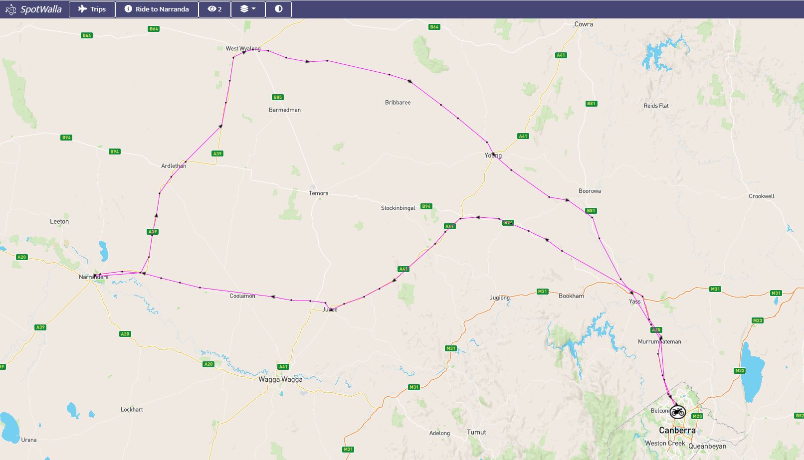
I have been using Spotwalla since 2009 and it is my go to tool for all long distance riding including my 2015 ride to WA including a 50CC (50 hours coast to coast) ride which has been my biggest endurance ride to date.

If you don’t need a satellite tracker then Bubbler is a great app to use with Spotwalla for general tracking, but where you need full and live coverage I would recommend a satellite tracker such as SPoT with Spotwalla. Link to Bubbler in Google Play.
Geo Tracker
The advantages of SPoT and Spotwalla is that you can share where you are with friends and family updated every 5+ minutes. But Spotwalla only provides an indication of your path based on the series of gps points.
For our trip to Switzerland and knowing that we were going ride lots of mountain passes I was interested in not only where we went and all the little backroads we would travel on and all the little villages we would pass through but also the shape of the terrain we were riding over. Our mountain ranges here in Australia just aren’t the same so I was really interested to see just how high and steep the passes were.
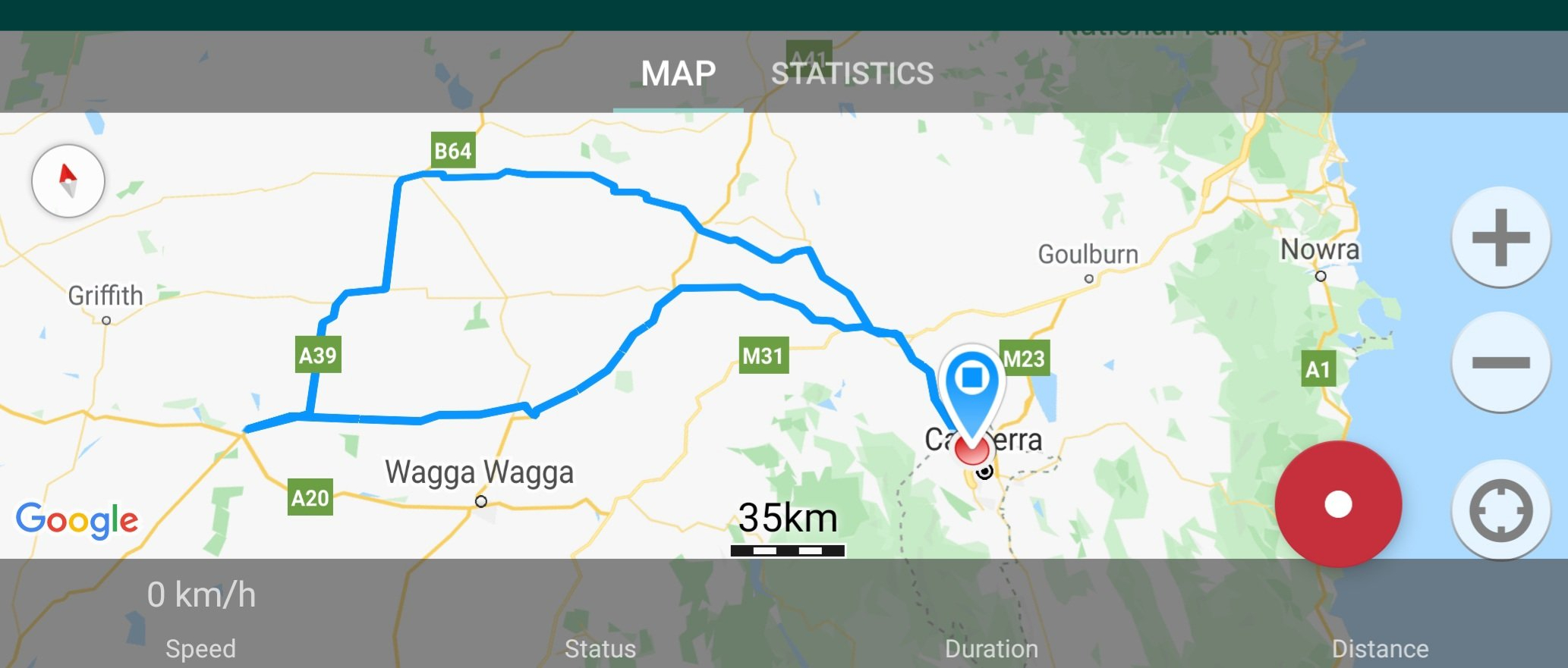
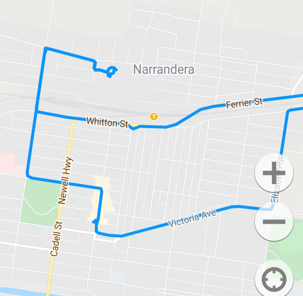
Prior to our trip to Switzerland I have tried a number of apps and settled on the Geo Tracker as it provides good functionality, a good interface, records your GPS location and provides a map of your route and a range of statistics of your ride. You can then save each of your trips separately for later reference.
Here are a few screen shots from Geo Tracker for the Narrandara ride.
And a screen shot of the ride profile from our Switzerland ride when we rode over Stelvio Pass in northern Italy going from around 1,100m to 2,800m and back down to 500m over about 60km as we wound our way up and over Stelvio Pass.
I really like this app and use it quite a bit and haven’t had any issues with it. Link to Geo Tracker in Google Play.
Relive
“Relive creates memories worth sharing. Get out there, and inspire others with your unique outdoor adventures.“
Relive combines a few different things, it gives you the ability to trace your ride/activity, track the profile, add photos of your trip along the way and creates a video of your trip incorporating the route, your photos, towns you pass through, the profile of the terrain and a number of other items. Relive then provides a link to your video to share.
I’ve used Relive a number of times and its very easy to use as all you need to do is hit start as you leave and stop when you finish. Once you are finished it presents all the photos you took along the way for you to choose which to incorporate in the video. Based on this Relive then makes your video. It’s that easy.
The free version lets you do all the basic things but if you want to use any of the additional features such as HD videos, editing videos, adding music, long trips, and playback speed, you have to pay a monthly subscription of US$6.99.
Here is my relive video of my trip to Narrandara.
As I like to tell the story of my rides, I really liked the concept of Relive when I first saw it. However after using it a few times, it really hasn’t captured me, yes it does what it says on the box but for me that’s not enough. And I don’t see the value of the monthly subscription. The only way I see myself using Relive (outside of simply curiosity) is embedding it in a post, but then I wouldn’t want to be having to run multiple tracking applications simultaneously on a trip.
This app works well but it isn’t something that I would use very often. Link to Relive in Google Play.
So back to my original question … what are you trying to track and why?
Narrandara Water Tower murals
For a full list of the Silo, Water Tower murals I have found on our travels please see this page.


Excellent review and comparison of devices. After many years using my SPOT on long tours, Covid19 buggered things up. I loved my SPOT for the trip log, my personal safety and the peace of mind it allowed my wife while I was travelling solo all over North America. With travel limitations and the increasing subscription fees I decided that SPOT couldn’t be justified so my account is inactive. Personally I think the company should have reduced fees and kept customers.
LikeLiked by 1 person
Thanks. I totally agree, and I know lots of people who dropped their subscription for exactly the same reason. The first time I contacted them to stop my subscription they gave me a big discount to stay but I don’t see why you have to do that dance.
LikeLiked by 1 person
The other thing about Spotwalla is that you can have two sources of data (in my case) into it and you can then select which you want to display. I had trouble getting the Spot feed to work reliably but the SWConnect (or SWTracker these days) worked seamlessly. So I would configure either of the feeds to see what came up then left it at that. From what I can tell, the upgraded Spotwalla site offers you the option of combining different feeds into one displayed map.
LikeLiked by 1 person
Or location pages where Jason can set up a page to show many users’ locations on one pottage.
LikeLiked by 1 person
Great review. I also dropped my SPOT due to subscription, moved to a KTI PLB. On the track side I moved to GeoTracker when my Garmin failed on a hot day in the middle of a ride. Selected and downloaded GeoTracker in Maffra Victoria as a temporary solution, but after several years still my go to GPS tool. GeoTracker, powerful, easy to use, shares data in standard formats. My phone is full of rides I can revisit including statistics.
I then write my rides up on Google maps with photos, for myself more than anything and share on any platform of my choosing. Too easy.
Once a year I revisit Relive, but so far have stayed with GeoTracker.
LikeLike
Thanks.
LikeLike